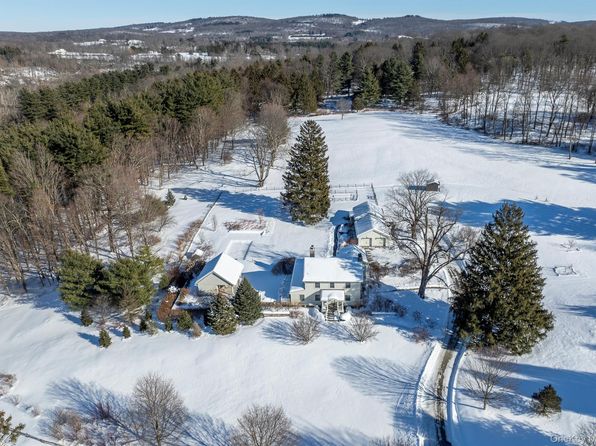

Crime & Safety Report for 188 Nine Partners Lane, Millbrook, NY 12545

Review crime and safety information near 188 Nine Partners Lane, Millbrook, NY 12545. HoodScore summarizes nearby reported incidents, registered sex offenders, and neighborhood safety indicators to help buyers and renters perform better location due diligence.

Generated At — 2026-07-26

Distance rings: 1 mi and 2 mi from the property.

PropertyIncidentsOffenders

Unlock the full safety report before making a decision about this neighborhood.

Full report contains 2 offenders within 5 miles and 88 crime incidents in the last 12 months.

2 Registered Sex Offenders within 5 miles Near 188 Nine Partners Lane, Millbrook, NY 12545

2 Registered Offenders Nearby
1 Rape
0 Child Involved
0 Assault
1 Other
Photo Name / Age / Tags Arrest / Conviction Address Distance Risk
Offender photo

RICCIARDI, STEPH

years old

Rapist

130.30 - Rape-2nd:Person 18 Yrs Old Or More Has Intercourse With Person<15 Yrs

2024-10-03T12:42:28

3220 SALT POINT TURNPIKE Clinton Corners, NY
5 Medium

88 Crime & Incidents in the Last 12 Months

88 Crime & Incidents by Severity
21 Severe
9 Medium
2 Low
56 Other
Crime Location (Approx.) Severity Description

Rescue / Entrapment

07/16/2026 02:18 PM

Flint Rd, Millbrook, NY 12545

Unknown

As discussed during the dispatch call, emergency crews were dispatched to a building near Flint Road in Millbrook for a reported person stuck in an elevator on the first floor. Units from the Union Vale and Unionville area responded to assist with the rescue and lift assist.

Medical Emergency

07/16/2026 12:17 PM

Stanford Rd, Millbrook, NY 12545

Unknown

As discussed during the dispatch call, dispatch reports a possible medical emergency involving an unresponsive but breathing adult woman near Stanford Road and Sharon Turnpike in Millbrook. A volunteer unit is noted as arriving on scene.

Fire

07/16/2026 04:51 AM

Franklin Ave, Millbrook, NY 12545

MEDIUM

As discussed during the dispatch call, fire units are responding to a reported small fire near Franklin Avenue in Millbrook, New York.

Medical Emergency

07/14/2026 06:30 AM

St Josephs Dr, Millbrook, NY 12545

Unknown

As discussed during the dispatch call, medical call for a 37-year-old woman with high temperature and feeling ill in the front room of a building near St Josephs Drive.

Fire

07/12/2026 04:31 PM

Flint Rd, Millbrook, NY 12545

MEDIUM

As discussed during the dispatch call, fire units are dispatched to an automatic fire alarm at an apartment in a residential complex on Flint Road in Millbrook, near Gifford Road and Camby Road.

Nearby Schools

Schools within 2 miles of this property, nearest first.

SchoolDistance
ALDEN PLACE ELEMENTARY SCHOOL0.5 mi
MILLBROOK MIDDLE SCHOOL0.6 mi
ELM DRIVE ELEMENTARY SCHOOL0.7 mi
MILLBROOK HIGH SCHOOL0.7 mi

Similar properties in Millbrook

Other for-sale homes in Millbrook within about 20% of this listing's price. Open a property for a HoodScore safety preview.

$2,999,999
3 bd | 5 ba | 4,134 sqft
97 Valley Farm Road
Millbrook, NY, 12545
View Safety Report

Frequently asked questions

Is 188 Nine Partners Lane in a low-crime area?

The current report summarizes crime-related incidents within 5 miles during the last 12 months. HoodScore compares these records with relevant benchmarks, but no report can guarantee future safety.

Why are traffic and medical calls shown separately from crime?

Traffic, medical and fire records are public-safety incidents but are not necessarily crimes. HoodScore separates them to avoid overstating the crime count.

How often is this HoodScore report updated?

The report displays its generated date. Update frequency varies by source and is explained in the HoodScore methodology.

How is the HoodScore calculated?

HoodScore combines nearby crime and offender data into a neighborhood safety score. Visit https://www.hoodscore.com/hoodscore-calculator.html to see how the calculation works.